Ireland is organized into 32 counties with the County of Galway being on the central west coast with a current day population of over 250,000 inhabitants. Counties are further organized by Civil parishes, Roman Catholic parishes, Church of Ireland parishes, Baronies, Registrar’s Districts, and Poor Law Divisions which were created at various times in Irish history and do not necessarily correlate with one another (e.g., RC parishes are typically larger than civil parishes but smaller than Poor Law Divisions). Also, in some cases, these parishes and divisions cross modern day county boundaries. To simplify this discussion, we will focus on Civil parishes in Galway.
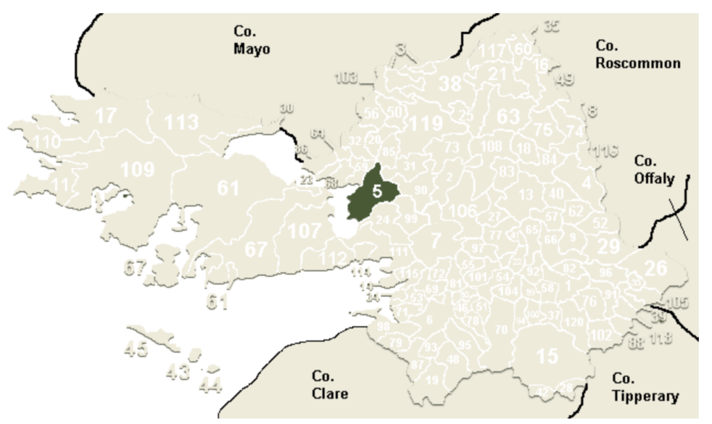
There are 120 Civil parishes within the county of Galway. Annaghdown is located ~ 11 miles north of Galway City on the eastern shore of Lake Lough Corrib as shown in Figure 1 below.
(source: johngrenham.com)
The Flaherty family was identified as originating from Annaghdown Parish based on the following key pieces of information:
- Bert Flaherty’s paternal grandfather Patrick Flaherty lived with Julia Flaherty Burke and Thomas Burke in Sacriston in the 1871 England Census. In the 1861 England Census, Julia and Thomas list that they are from “Galway, Anadown, Ireland” and “Galway, Kilcoony, Ireland,” respectively. Kilcoony most likely refers to Kilcoona Parish which is located on the north boundary of Annaghdown (number 59 on Figure 1).
- DNA matches have confirmed records of Flaherty surname ancestors being from multiple townlands within Annaghdown (see below) and the townland of Mausrevagh in Kilcoona Parish located only a few miles north of the Annaghdown border. (Note – Ireland refers to towns and villages as townlands).
- Mary Forde from the townland of Balrobuck More in Annaghdown lives with Bert Flaherty’s aunt Bridget and Hannah in Parsons, PA in the 1900 Census. Her mother was Sarah Flaherty who eventually joins Mary and her siblings in Parsons.
Annaghdown Parish takes its name from Gaelic “the marsh of the fort” with the first mention of Annaghdown in written records being in the 12th century. The parish is mainly rural and flat and comprised of small towns and villages, farmland, and marsh. The Annaghdown Heritage Society has many resources relative to the history of Annaghdown and genealogical records.
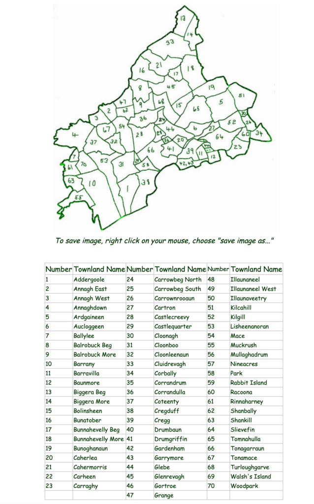
In an effort to determine where within Annaghdown Parish the Flaherty family came from, multiple sources were used. There are 70 townlands within Annaghdown as shown below in Figure 2.
Ultimately, it has been concluded (but not 100% confirmed), that Bert Flaherty’s father Patrick and paternal grandfather Michael most likely came from the townland of Grange (Number 47 on Figure 2 [center of north boundary]). This is based on the following:
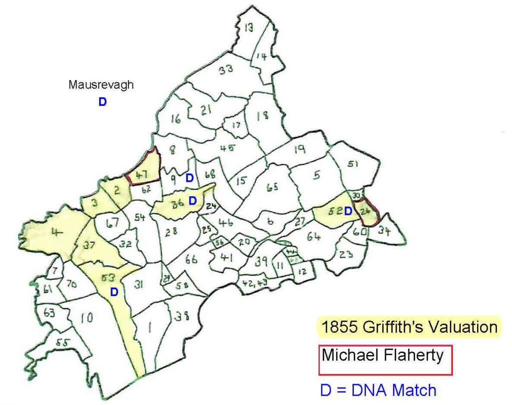
- The Griffith’s Valuation shows that there are 20 Flaherty’s who are land tenants in Annaghdown in 1855 (note – the Valuation lists those who were land tenets in the townland by section of land so the same person may be listed multiple times if they were tenants on different sections of land). Flaherty’s are located in the following townlands (# on Figure 2) and shown below on Figure 3 in yellow:
- John, two Michael’s, Michael Jr, Thomas in Grange (#47)
- Two Margarets and two Hugh’s in Annagh West (#3)
- Patrick and two Mary’s in Annagh East (#2)
- Three Michael’s in Carrownrooaun (#26)
- Martin in Annaghdown (#4)
- Patrick in Lisheenanoran (#53)
- John in Coteenty (#37)
- John in Corrandulla (#36)
- Margaret in Kilgill (#52)
- As can be seen on Figure 3 below, the Flaherty’s congregate in the townlands along the western northern border with other singular Flaherty’s found in scattered townlands. Bert Flaherty’s grandfather Michael would be expected to be a land tenet in 1855 assuming that he was still alive (Michael’s death date has not been found). A Michael Flaherty is only listed as being a land tenet for Grange (#47) and Carrownrooaun (#26) [see red borders].
- DNA is shared with multiple people whose Flaherty surnamed ancestors lived in Annaghdown Parish. Civil and baptismal records for those individuals are found the following townlands (see “D” identifier on Figure 3): two from Balrobuck More (#9), one Corrandulla (#36), one from Lisheenanoran (#53), and one from Kilgill (#52). In addition, there is shared DNA for a descendant of Hugh Flaherty from Mausrevagh, Kilcoona Parish which is a townland ~ 2.5 miles north of Grange.
- A more detailed map was made of the Annagh East and Grange as shown below reflecting all of the names contained within the mid-1800s Griffith’s Valuation in Figures 4 and 5 below.
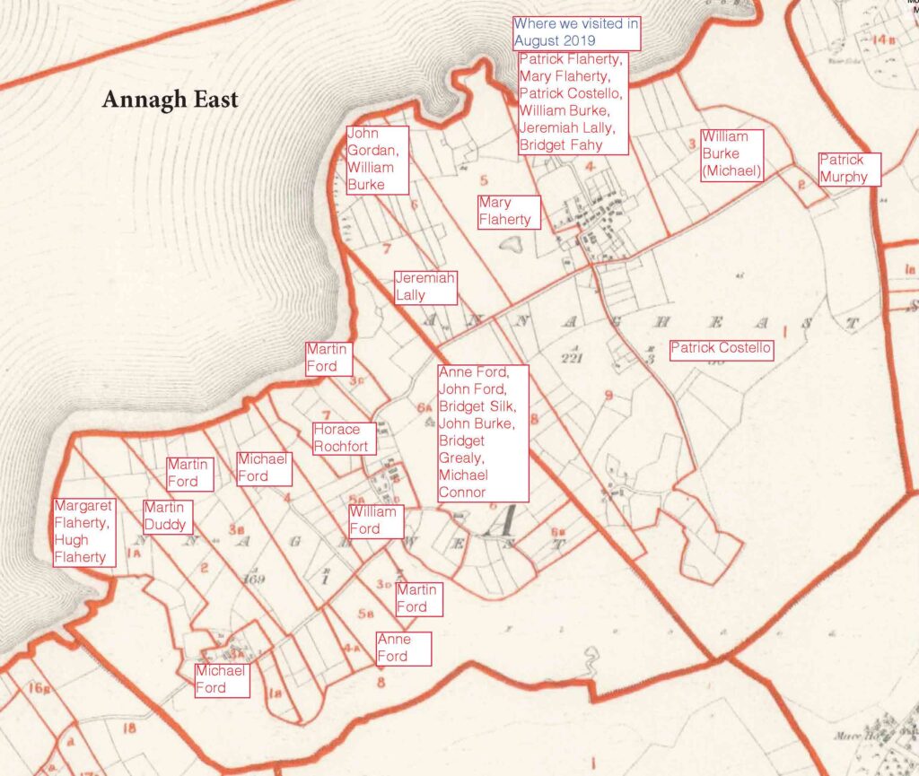
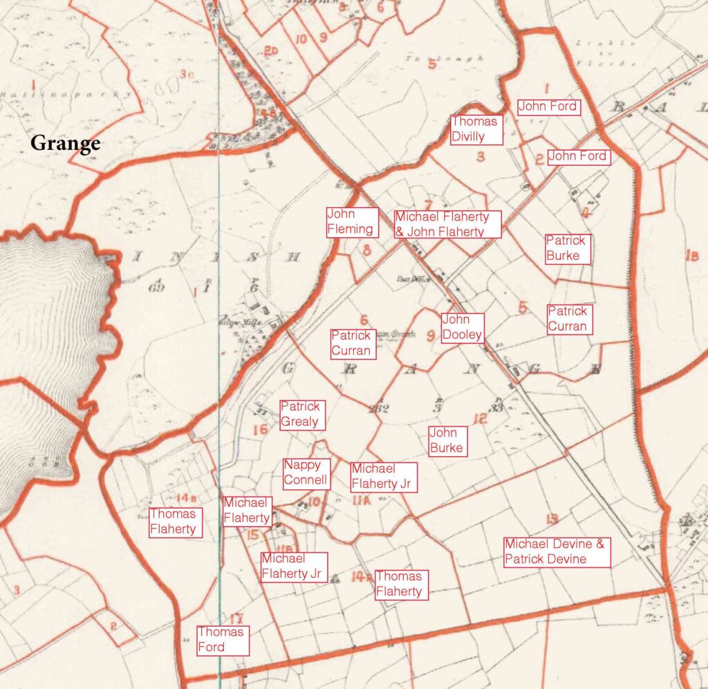
The Annaghdown Heritage Society has a page dedicated to Grange and Annagh East includes significant details from multiple record sources from the early 1800s to early 1900s. Some of the more interesting highlights from Grange include:
- The 1901 Census of Ireland shows 12 households in Grange, of which 6 have a parent whose surname is Flaherty. Included is Sarah Flaherty Forde who as described above immigrates to Parsons, PA in 1911 along with her two youngest children shown in the census. Prior to the 1901 Census, several of Sarah’s children immigrate to Parsons including daughter Mary who lives with Bert’s aunts Bridget and Hannah in the 1900 US Census.
- All of the houses in the 1901 and 1911 Censuses are constructed of stone with a thatched roof and have 1 to 4 rooms with 1 to 4 front windows (see more in Grange Today section below).
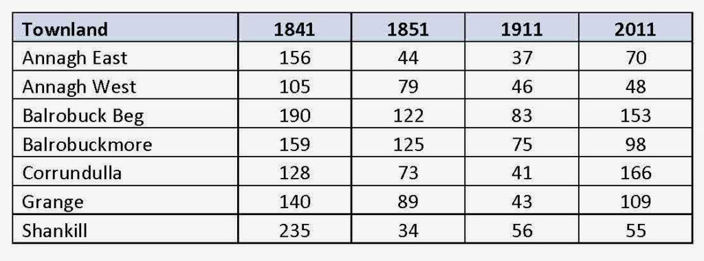
- The population of Grange dropped by over 1/3 during the time of the Irish Famine (see Figure 4 below) and continued to drop through the early 1900s such that the population in the 1911 Census was only 32% of that in 1841. In 2011, the population had increased to 109 people (78% of 1841 population).
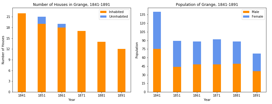
Even larger population drops are seen in the townlands surrounding Grange over this same time period.
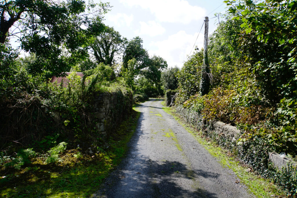
Grange and Annagh East Today
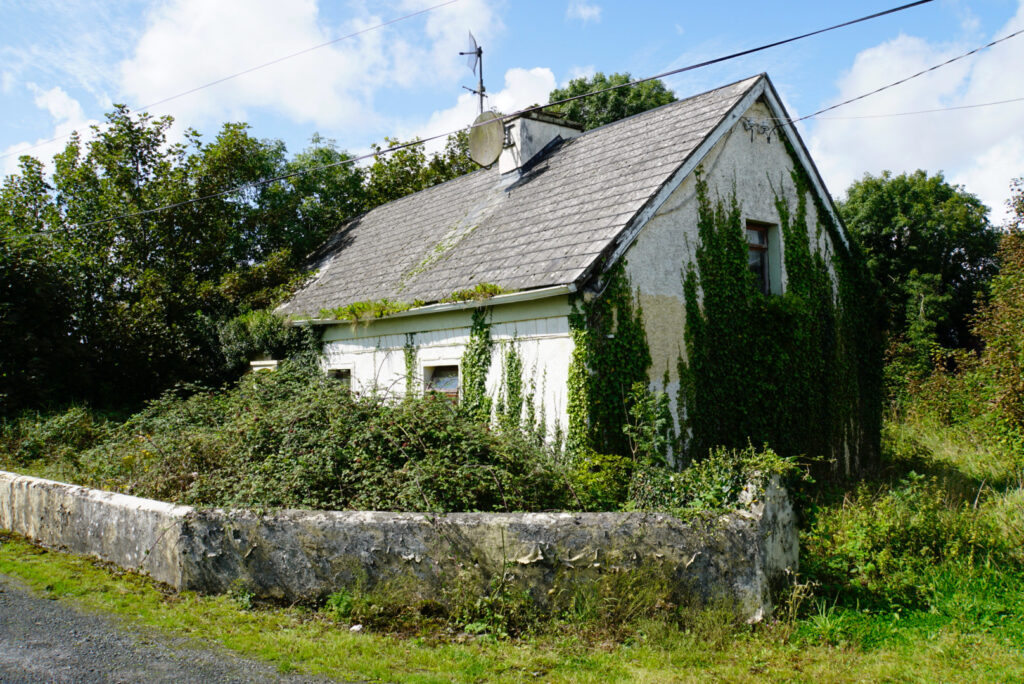
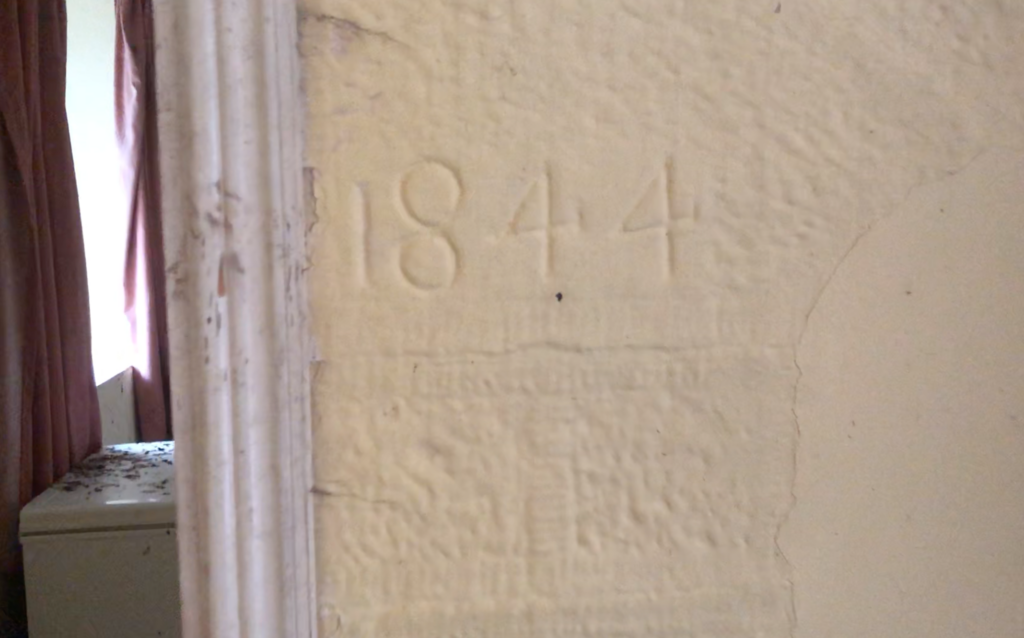
In August of 2019, my family and I were able to visit Annaghdown and meet with several Flaherty’s who lived in the area. The visit was arranged through My Ireland Family Heritage and was an incredible and enriching experience. Based on research completed at the time, our visit focused on Annagh East (townland to the west of Grange). Several pictures of the visit are provided below including pictures of a home built by Hugh Flaherty in 1844 in Annagh East. Hugh is not listed in the 1855 Griffith’s Valuation as a land tenant, only a Patrick and Mary Flaherty are listed. This implies that Hugh potentially died during the famine and his wife Mary and surviving children lived in the home.